Sewerby, Bridlington to (not quite) Flamborough Head – November 2023

This was fantastic walk from Sewerby around the coast and heading to Flamborough Head by the England Coastal Path. I was lucky with the weather but the going was hard work as you head north and the trail turns to heavy, wet mud. The path is mainly turf, or quagmire, dependent on the local drainage.

A spell of dry weather and no more rain from storms like Storm Ciarán (around the time of the walk) would help!

I parked next to the Methodist Church in Sewerby. Foolishly, the council close the public car park in the winter and it isn’t accessible until March next year. Expect to be sniffed at by lots of well-behaved dogs but they, and their owners soon fall behind as you head north.

As seems to be typical walking off the North Sea, thye day started grim and obvercast. It still looks beautiful in my eyes, but it was pleasant to see blue skies gradually appear, miraculously as forecast…

The approach to Danes Dyke Beach:

It’s an beach full of chalk cliffs and the sea has rounded the chalk stones into many different sized ‘egg’ shapes.

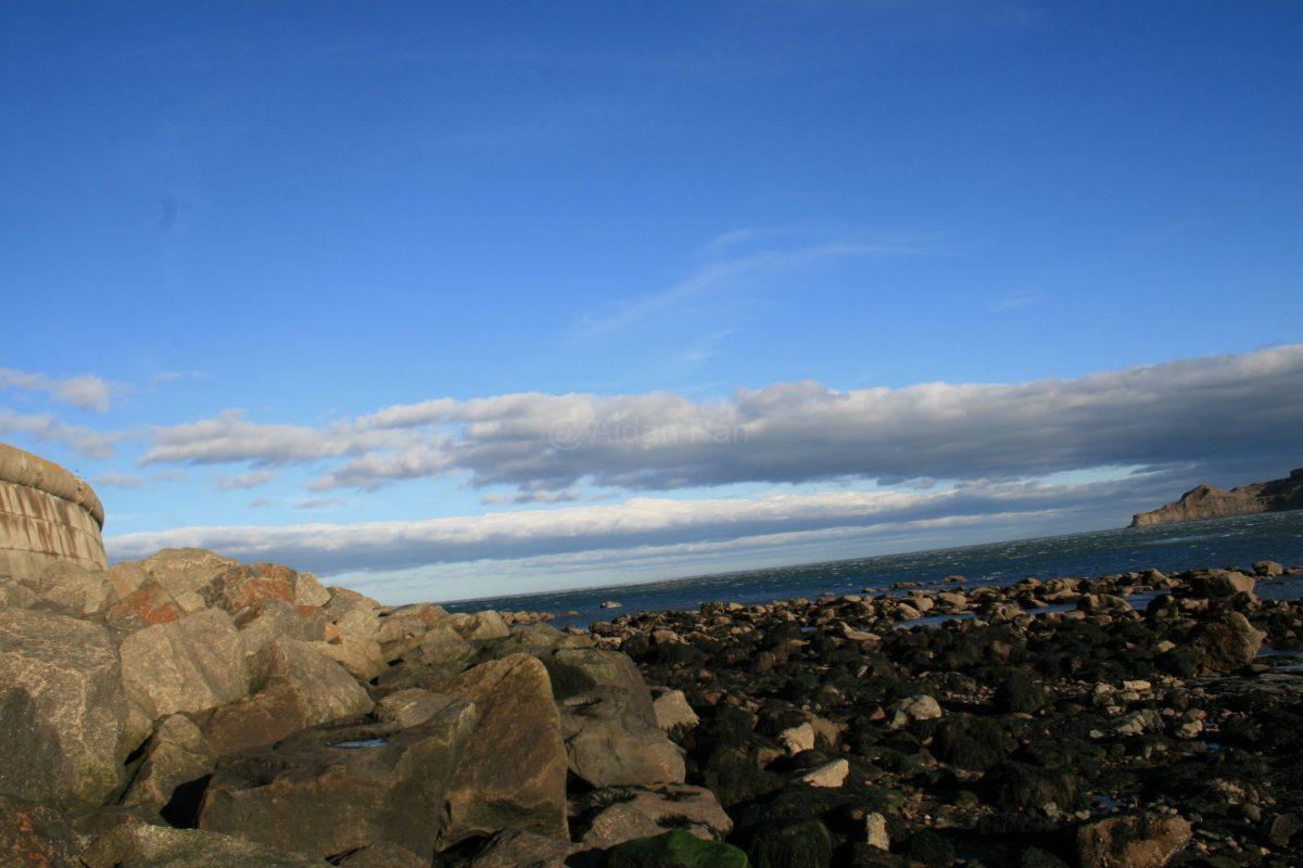
Then it’s up and steps (yet again…) but the day was distinctly improving with blue skies and white clouds slowly appearing:

And just about to spot South Landing Beach in the distance:

It’s another beautiful spot with large limestone rocks rounded by the sea.
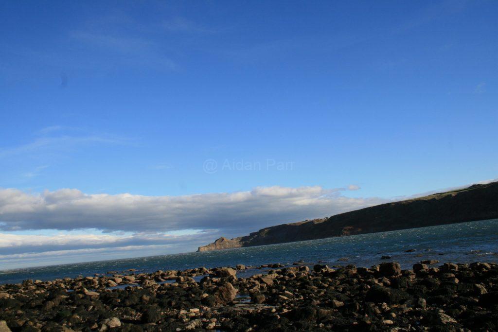
Ascending again:

At this point it has become a beautiful day with big blue skies and clouds (my favourite)…

Unfortunately the path starts to turn into mud at this stage and walking is hard work!

I battled on, enjoying scenery but not the footing:

This is where I stopped and turned back. The ground was seriously muddy and claggy which saps energy. Ahead was a sharp incline that I would have had to slither down on my backside with little chance of getting back up it!

The last picture picture before turning back:

I walked to Flamborough village and caught the bus back to Sewerby. Timetable here.

It’s a beautiful place but the path is walkable dependent on the weather. November 2023 had a shocking amnount of rain and named storms, so it’s no surprise the ground was in such a state. It woulkd be nice to go back in drier conditions.

And lastly, some videos of the walk:

A Little Bit of Runswick Bay, North Yorkshire Coast – November 2022

These are a few pictures of Runswick Bay on the North Yorkshire Coast taken in November 2022. It’s about 2.5 miles by car from Staithes and a 3 mile walk on the Cleveland Way.

You can get a bus back to Staithes or down the coast south to Scarborough and beyond. Check the timetables – be aware they might change!

It’s a very beautiful spot but I imagine it would be very busy in the summer. It being November and a windy day, there were hardly any people about – which is nice!

And lastly, a video of the bay…

Robin Hood’s Bay to Whitby – November 2021

This was a walk in north Yorkshire from Robin Hood’s Bay to Whitby via the Cleveland Way on an unusually sunny and warm day in November 2021. It’s got to be one of my favourite walks with blue sky full of many different sorts of clouds and dark seas below. At times, it was very blustery but remained warm.

It’s hard to get very good pictures with the sun so low in the sky and I struggled to take them without my shadow appearing! My camera, an antique Canon 30D takes good pictures but it does benefit from stronger sunlight. I’m still pleased with many of the pictures but it doesn’t quite capture the glory of the day.

It was at this point I did think about turning back. The streams (know locally as becks) means many descents and ascents on the Cleveland Way. There was a bit of a bit of muttering about ‘the joy of becks’ at this stage. The steps can be very slippery, especially the sections that are smoothed stone covered in mud.

I thought I’d walked further but I’d only done less than half way. Fortunately I’m stubborn, so I carried on and hoped for more level walking. Silly me!

God bless Colin Thompson and his bench!

I’m not sure it’s wise to obstruct the first view of Whitby Abbey from the south with a caravan park:

After that, it’s the descent via the 199 Steps to Whitby.

To be honest, I didn’t find Whitby very inspiring, hence no pictures. If you like places full of older, aimless and bored tourists looking in shop windows, it will suit you well. The lack of friendliness and engagement is a complete contrast to that of walkers I met on the way.

The bus back to Robin Hood’s Bay was welcome!

It’s the most wonderful walk along the coast with beautiful views and big skies but it is a challenge if you aren’t very fit (like me). However, I’d do it again like a shot!

These pictures and videos are @Aidan Parr 2021, so please ask permission if you want to use them. I’ll probably say ‘yes’!

Ravenscar to Robin Hood’s Bay and Back Again – November 2021

This was a walk in north Yorkshire from the hamlet of Ravenscar along the cinder track of the former Scarborough to Whitby railway line to Bay itself and then back via a section of the Cleveland Way.

The day started misty and dark but ended up as a glorious day with sun and blue sky – very unusual for November.

The cinder track mostly stays in shade this time of year so it’s a good deal cooler and damper than on the seafront cliff edge which catches the low winter sun. However, it’s a relatively easy walk, about 5.5 miles gently sloping down to Robin Hood’s Bay and into Bay itself.

Be warned that if you’re thinking of eating in Bay, many places are closed for the season or opening times are later. Both fish and chip shops don’t open until 4.30pm, so no treat for me!

I walked back by the Cleveland Way to Ravenscar. I found it very challenge as the trail descends down to where local streams (known locally as ‘becks’) run into the sea. The trail is well looked after and has steps but it is hard work getting up and down these inclines. It’s probably not for the faint-hearted or if you have dodgy knees or a bad back!

On a positive note, the views are spectacular. Spot the pillbox falling into the sea and the myserious standing stones, if you can!

The sunset was what you might call ‘unusual’.

I was out walking for over eight hours and returned to my car completely shattered but very happy. If I’d known, I’d had probably walked the Cleveland Way section first and then come back via the cinder track.

C’est la vie!

These pictures and videos are @Aidan Parr 2021, so please ask permission if you want to use them. I’ll probably say ‘yes’!

The Rest of Spurn Head, East Riding – August 2021

I really enjoyed going to Spurn Point a couple of weeks ago. The post and pictures are here.

I didn’t get to walk much of it because of problems with my foot and I was unprepared for the walk! The herculean task awaited and I couldn’t resist the challenge. Seven hours and 8.5 miles later I got back to the car with sunburn, a sore back, knees and foot but happier than I’ve been in ages.

It’s a peculiar place. The further south you walk, the more lonely it feels. The washed away road lies in huge rafts of concrete scattered around like toys for giants. The remnants of Spurn Head’s history are also scattered about: the ruins of fortresses and the worn remains of anti-Tank blocks from the Second World War litter the beaches at low tide.

There’s eroded brickwork and mysterious concrete shapes everywhere.

Nearly everything made by human hand is in ruin leading to more impression of desolation, the exception being the RNLI station and housing for their staff. It leads to some reflection on the futility of battling the sea and how we tend to think we have mastery of nature.

On a more positive note, nature bursts forth everywhere and it is overwhelming Spurn Head’s history, good and bad.

Happily the walk back north on the beach on the eastern side was much more wild and empty. As you head north, though, there’s more remnants of man’s broken constructions.

That’s enough deep thought for now… thankfully!

There’s far too many pictures as the sky was beautiful and the coastal features were incredibly photogenic.

I’ve split the pictures:

Birds:

Flowers:

Sea, sky and ruin:

Check the high tides as Spurn Head can be cut off at it’s narrowest point, a mere 50 metres wide. Do also look at the signs at the car park about safety if there is a high tide.

Go to the Yorkshire Wildlife Trust website for more information about the area and better photos…

I recommend the fry up in the cafe at the Spurn National Nature Reserve.

These pictures and videos are @Aidan Parr 2021, so please ask permission if you want to use them. I’ll probably say ‘yes’!

Saltfleetby, Lincolnshire – June 2021

This is another favourite walk and a beautiful beach. It’s another one of those places that’s too wild for too much commercial activity, so recommended by me!

Free parking right next to the beach which is also recommended.

I headed south from Saltfleetby, along Mogg’s Eye and turned back just after Anderby Creek. There’s a cafe there where I enjoyed a fried breakfast.

It was one of those ‘beautiful skies’ day, so there’s far too many pictures of clouds and blueness…

These pictures and videos are @Aidan Parr 2021, so please ask permission if you want to use them. I’ll probably say ‘yes’!

Chapel St. Leonard’s Beach, Lincolnshire- July 2021

This was from a walk from Chapel St’ Leonard’s heading north on the beach. About six miles.

I didn’t find the town itself very exciting. It was very quiet when I arrived around 8am. It was a lot busier later in the day. A lot of people go there to retire.

I parked in Parklands car park which is a ten minute stroll from the sea front.

I wouldn’t exactly classify this as ‘an exciting walk’ but it was pleasant enough: a warmish sun, a fresh wind and probably five or six people at the most, getting very busy around 11am.

You can see the excitement of Skegness in the distance if that’s your thing?

Some curious lumps of petrifies wood. I thought it might be a piece of forest from Doggerland, then name given to the land that is now under the North Sea. It might also be from a ship?

These pictures and videos are @Aidan Parr 2021, so please ask permission if you want to use them. I’ll probably say ‘yes’!

Anderby Creek, Lincolnshire – June 2021

A lovely walk from Anderby Creek heading south on the Lincolnshire Coast. A hidden gem!

The car park is directly on the beach.

There’s also a cafe next to the car park serving breakfasts, burgers and chips – the usual healthy fare beloved by the British! The fry up breakfast after the walk was ok.

I don’t think I’ve done the place any justice with the pictures but I enjoyed seeing the horses enjoying some salt water therapy – see the video below (edited).

These pictures and videos are @Aidan Parr 2021, so please ask permission if you want to use them. I’ll probably say ‘yes’!

Cayton Bay – July 2021

Cayton Bay: this is probably one of my favourite beach walks. It’s very small at 1.5 miles from end to end but it’s beautiful and isolated. The weather was glorious with strong sunshine from early morning.

You’ll spot Scarborough Castle and Scarborough itself in some of the pictures but it could be a thousand miles away. Just be warned, it’s a very steep descent to get to the beach and a knackering ascent to get back up again!

You’ll find an easily accessible car park near the steps down to the beach. The steps themselves are a challenge as I’ve mentioned.

I just added the pictures of the remains of pill-boxes from the Second World War which are dotted along this coastline. They were meant to help defend the country if there was a Nazi invasion.

Many are now in ruins because coastal erosion has sent them plummeting from cliffs above down to the beach. Occasionally they survive on beaches in good order. They knew how to make stuff then!

These pictures and videos are @Aidan Parr 2021, so please ask permission if you want to use them. I’ll probably say ‘yes’!

Filey Bay – July 2021

I had an enjoyable walk along Filey Bay at the end of July 2021. The town itself isn’t too exciting for me. It’s a perfectly acceptable Victorian seaside resort and gets very popular from late morning onwards. My interest was Filey Bay itself.

I’d originally intended to park on the north side of Filey and walk along the promenade and then on the beach heading south. Unfortunately none of the parking meters were working (neither cash nor card), so after fifteen exasperating minutes I had to move. I eventually ended up parking south of Filey at West Avenue Car Park. Be warned that credit and debit cards didn’t work there either!

Happily it was only a short walk to the beach. Beware of high tides as you head south. It’s perfectly ok to walk about three miles to Hunmanby Gap but then the high tides don’t allow much beach walking. Check high tides here.

There is a car park at Hunmanby Gap but it’s unclear what times it opens if you want an early start. There’s nowhere else to park and you’ll see lots of signs from locals about not blocking driveways. There’s a cafe too.

It was a wild and windy day with some rain but nothing to spoil the morning. The pictures make it all look very grey and forbidding but there were sunny spells ever so often!

Like much of this part of the Yorkshire coast, there’s a lot of coastal erosion and you can see the remains of pillboxes from the Second World War which have fallen from the cliff tops onto the beach. Some still intact!

It gets busy around 11am. A tiny number of visitors are loud and undesirable but the majority of people are perfectly ok.

Click on the pictures to see the area more clearly.

These pictures and videos are @Aidan Parr 2021, so please ask permission if you want to use them. I’ll probably say ‘yes’!