Castleton to Mam Tor and back to Castleton – Derbyshire – April 2022

Castleton is a village in Derbyshire and is part of the High Peak. It’s very busy tourist trap in the Spring and Summer and parking can be difficult. That’s why I set off very early from home and arrived at 6.30am for the walk.

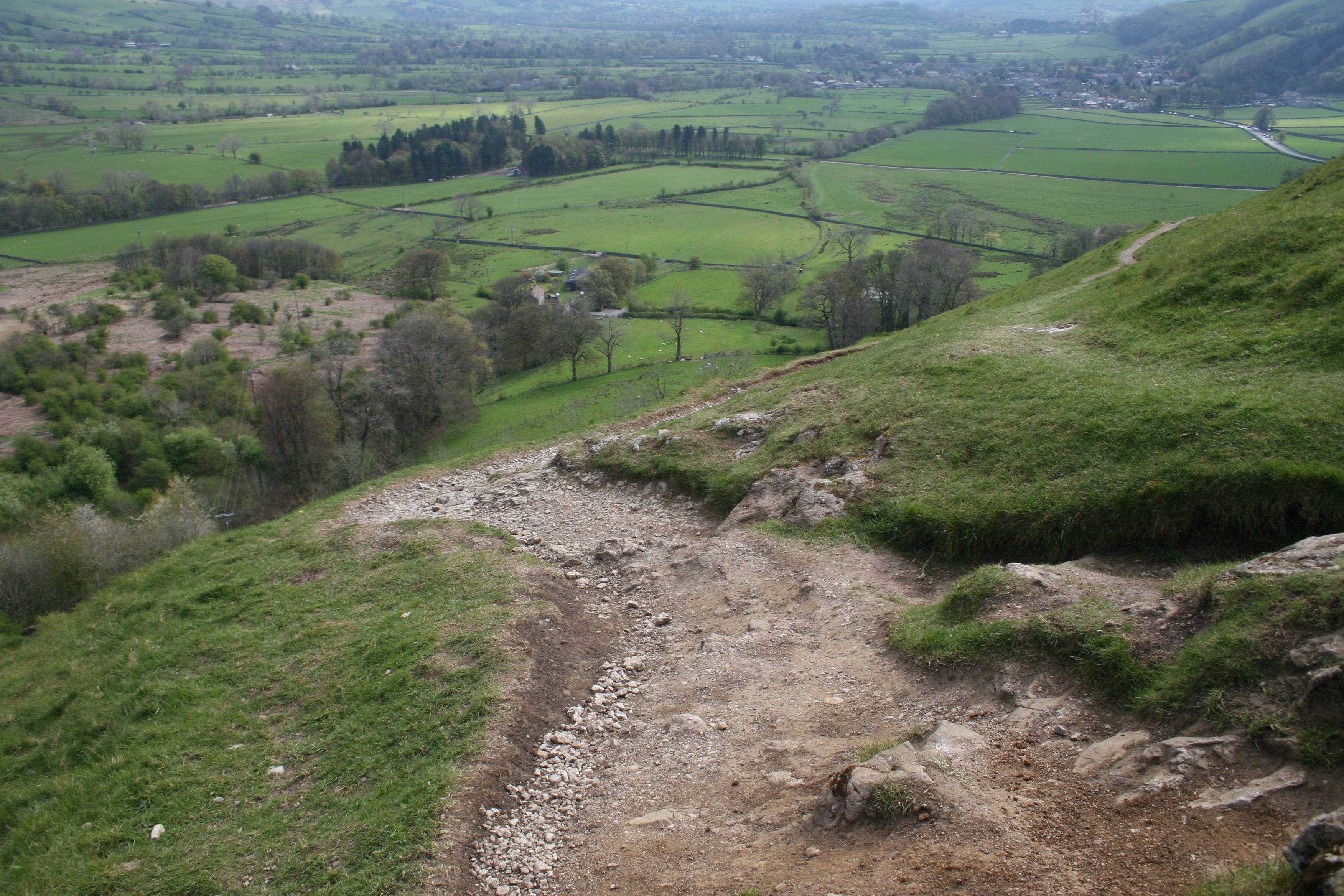
I headed north from the village and uphill to The Great Ridge. It’s very steep and as you’ll see, can be a challenge to navigate in parts: rocky, muddy and sometimes with running water. Stout walking boots with good ankle support are recommended.

The ascent took me around 90 minutes including breaks and time to enjoy the scenery as I got higher. Don’t be afraid to plonk yourself down on a handy boulder for a breather – you’ll enjoy yourself much more.

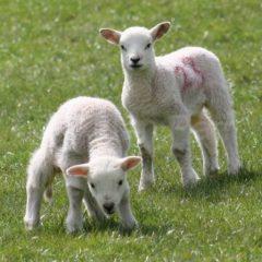
There are a lot of sheep with lambs this time of year…

Plus a supremely disinterested cat:

Then it’s onwards and a lot of upwards:

A breather…

And some more upwards…

The view from the Great Ridge is worth the ascent, though.

Then it’s off west to Mam Tor with some more upwards but this time with more gentle inclines.

The day began to brighten!

Then you’re at Mam Tor, the ‘mother hill’. The monument is at the site of a bronze age fort. It allows another great view of Castleton on one side and Edale on the other.

Then it’s all downhill:

Personally I found the entrance to the Blue John Cavern rather uninteresting and at £15 to get in, unlikely. I did enjoy a cup of tea while admiring Mam Tor. Shame about the camper van?

Downwards over the brow of the hill. The walk is a little rough with fine limestone and it’s easy to slip while enjoying the view.

A better view of Mam Tor. You can see where the hillside has repeatedly fallen away.

More sheep and lambs:

And a look at Winnat’s Pass while heading back to heading back to Castleton. It’s spectacular to drive though and the picture and video hardly does it justice. Some hang-gliders too!

And lastly, The Devil’s Arse, if you like that kind of thing…

High Peak Trail: High Peak Junction to Middleton Top – Derbyshire – March 2022

This is a trail using the remnants of the former Cromford and High Peak Railway which ran from Cromford Canal, south of Matlock, to Parsley Hey, where it meets the Tissington Trail heading north.

Although it looks bucolic, it’s actually a very industrialised landscape built for the Industrial Revolution and the transport of raw and finished goods. The whole area is pocked-marked by small ancient quarries and their huge modern equivalents.

It is a challenging walk at the beginning because of the inclines, some of them 1 in 8. For an unfit walker, it’s a gasp a minute!

The struggle upwards is worth it for the view…

Then onwards and upwards. I love the archway of the bridge over the trail.

Another lovely view…

And then back again to High Peak Junction…

The rock formations, blasted by explosives and hacked at by hand to create the train line are fascinating.

Stanage Edge, Derbyshire – September 2020

This was a walk along Stanage Edge in Derbyshire, one of those gritstone ridges common to the area. It’s a beautiful and wild place!

I parked my car at Upper Burbage Bridge Car Park and then walked across the moors. Be warned it can be a very popular walk and tricky to find a car space, so start early in the day.

Not many pictures and it was done by my phone camera and the quality isn’t so good but it captures something about the place. The views are fabulous!

Spot the hang-glider…

Birds on the Feeder – closer to home, Derbyshire – January 2021

Greenfinches, bullfinches and blue tits in the back garden, on the feeder in January 2021. They are territorial little sods!

The pictures aren’t that great at times because the camera was quite new to me and I had to shoot through a double glazed window. It’s impossible to be outside without alerting the birds – even the click of the camera makes them fly away.

I’ve since tried with a tripod and a remote control (me inside and out if direct view) but it takes them about a week to get used to the new ‘thing’ in their environment and the camera clicks still send them scattering.

You’ll also see how fast they can be when they fly…

These pictures and videos are @Aidan Parr 2021, so please ask permission if you want to use them. I’ll probably say ‘yes’!

From Etwall (nearly) to Eggington Junction, Derbyshire – February 2021

This is yet another old railway line which would have run from the now defunct Derby Friargate Station to Etwall and then joining the mainline south of Eggington Junction.

It’s not a terribly exciting walk but when we’d been in Lockdown I grabbed the chance for a short walk, despite the cold and the snow flurries! Luckily the sun came out later on the way back.

These pictures and videos are @Aidan Parr 2021, so please ask permission if you want to use them. I’ll probably say ‘yes’!

Jinney Nature Trail, Staffordshire – March 2021

The Jinney Nature Trail is the remains of old railway line that ran from Tutbury & Hatton via Rolleston-on-Dove to Burton-on-Trent. It closed in the 1960s thanks to the idiotic Lord Beeching and his drive to close many parts of the rail network as possible.

Happily it is now a short walk (about two miles) from Rolleston to the outskirts of Burton. This was my first chance to get out for a walk for ages and to be more than 9.9 miles from home, because of Covid restrictions. Any fitness is hard to acquire, but easy to lose!

Four miles was quite enough…

Spring is a favourite time of year, so there are as many pictures of flowers as possible!

These pictures and videos are @Aidan Parr 2021, so please ask permission if you want to use them. I’ll probably say ‘yes’!

Rolleston on Dove to Tutbury, Staffordshire – March 2021

This was a walk from Rolleston-on-Dove in Staffordshire, along the River Dove to Tutbury and back by a very quiet road and across country back to Rolleston.

If you’ve got time, Tutbury Castle is worth a look. Be aware that it is privately owned and opening hours are eccentric. At the time of this walk, the castle wasn’t open because of Covid.

There were lots of dramatic and changeable skies where it looks like you need to pack for every sort of weather: sunglasses, sunscreen, raincoat, hat and scarf. Fortunately, despite dark threatening skies, it remained dry with just a light shower for a few minutes.

It’s very English location with pretty villages, old churches, swans and spring flowers just starting to bloom, slightly spoilt by the Nestle factory in Hatton. Even if you ignore it visually, the smell of coffee can be overpowering.

This is the session I discovered that I had dirt on the CMOS sensor of my camera, so you might spot unidentified objects here and there. These are the perils of trying to understood what goes wrong with a ‘proper’ camera after using my phone for so long…

I thought it would be nice for the swans on the Dove near Hatton to get their own small section:

These pictures and videos are @Aidan Parr 2021, so please ask permission if you want to use them. I’ll probably say ‘yes’!

Earl Sterndale, Derbyshire – April 2021

This was an intended walk from Earl Sterndale to Chrome Hill, also known as The Dragon’s Back. Park outside the church, opposite ‘The Quiet Woman’ pub.

It was one of those days where intention and actuality don’t overlap and I didn’t get far. It’s a walk to definitely go back to but it requires a level of fitness I didn’t have on that particular day…

To be fair, I’d overdone the walking the week before at over nine miles and hadn’t quite recovered!

Enjoy the pictures of clouds and dramatic skies, the lambs at their gambolling and frolicking stage and daffodils.

These pictures and videos are @Aidan Parr 2021, so please ask permission if you want to use them. I’ll probably say ‘yes’!

The Rest of Spurn Head, East Riding – August 2021

I really enjoyed going to Spurn Point a couple of weeks ago. The post and pictures are here.

I didn’t get to walk much of it because of problems with my foot and I was unprepared for the walk! The herculean task awaited and I couldn’t resist the challenge. Seven hours and 8.5 miles later I got back to the car with sunburn, a sore back, knees and foot but happier than I’ve been in ages.

It’s a peculiar place. The further south you walk, the more lonely it feels. The washed away road lies in huge rafts of concrete scattered around like toys for giants. The remnants of Spurn Head’s history are also scattered about: the ruins of fortresses and the worn remains of anti-Tank blocks from the Second World War litter the beaches at low tide.

There’s eroded brickwork and mysterious concrete shapes everywhere.

Nearly everything made by human hand is in ruin leading to more impression of desolation, the exception being the RNLI station and housing for their staff. It leads to some reflection on the futility of battling the sea and how we tend to think we have mastery of nature.

On a more positive note, nature bursts forth everywhere and it is overwhelming Spurn Head’s history, good and bad.

Happily the walk back north on the beach on the eastern side was much more wild and empty. As you head north, though, there’s more remnants of man’s broken constructions.

That’s enough deep thought for now… thankfully!

There’s far too many pictures as the sky was beautiful and the coastal features were incredibly photogenic.

I’ve split the pictures:

Birds:

Flowers:

Sea, sky and ruin:

Check the high tides as Spurn Head can be cut off at it’s narrowest point, a mere 50 metres wide. Do also look at the signs at the car park about safety if there is a high tide.

Go to the Yorkshire Wildlife Trust website for more information about the area and better photos…

I recommend the fry up in the cafe at the Spurn National Nature Reserve.

These pictures and videos are @Aidan Parr 2021, so please ask permission if you want to use them. I’ll probably say ‘yes’!

Ashbourne to Mapleton, Derbyshire – April 2021

This walk started in Ashbourne right at the beginning of the railway tunnel which was once part of the train line joining Ashbourne to Buxton which was closed in 1963. It’s now the splendid Tissington Trail. I’ll cover that in another post.

Park in the Ashbourne Leisure Centre Car Park and you’ll see the tunnel. I cut across country eastwards when I got out of the other end of the tunnel, eventually walking along the River Dove.

The walk ends at the almost Orthodox-looking church at Mapleton. I returned by going up the hill behind the church and joining the Tissington Train back to Ashbourne. There’s lots of beautiful countryside, horses, sheep, donkeys, alpacas and other wildlife on the way.

Apologies if there are too many pictures, it’s sometimes hard to know when to stop when I’ve enjoyed a good day out…

These pictures and videos are @Aidan Parr 2021, so please ask permission if you want to use them. I’ll probably say ‘yes’!